Fabrizio Vazzana, Francesca Pepe
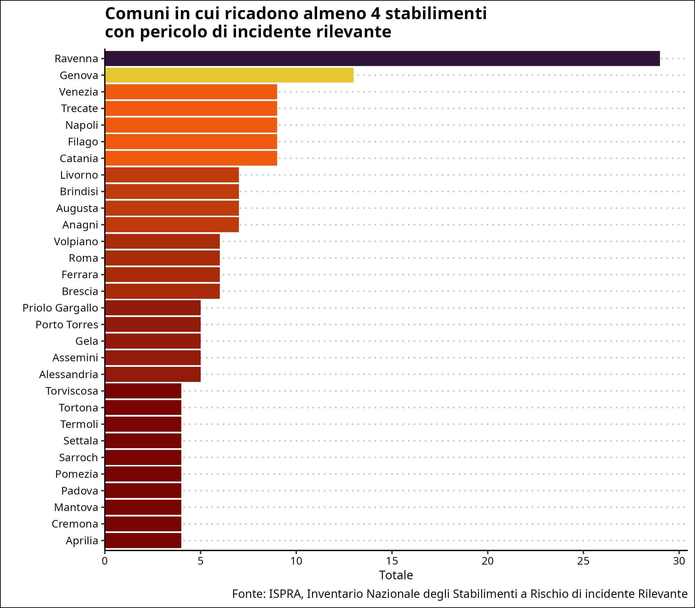
The indicator identifies areas with a particular concentration of establishments at risk of major accidents, providing useful information for territorial planning, particularly for land use and allocation. In 2026, there were 30 municipalities with four or more RIR (Risk of Major Accident) establishments, distributed across 13 regions: they host approximately a quarter of all establishments at risk of major accidents in Italy. The regions with the highest number of these municipalities are: Lombardy (5), Sicily (4), Lazio (4), and Piedmont (4). Among the municipalities characterized by a high number of establishments, Ravenna stands out with 29, Genoa with 13, followed by Trecate, Venice, Catania, Naples, and Filago with nine, Augusta, Anagni, Brindisi, and Livorno with seven each.
The indicator lists municipalities with notifiable major-accident risk establishments (lower- and upper-threshold establishments), as well as the number of establishments in each municipality. This indicator narrows the scope of the analysis by taking as a reference a smaller territorial area than the region or province, i.e., the municipality. Analysis of the indicator allows for further considerations regarding the map of major-accident hazards in our country. This information allows for a better understanding, at the municipal level, of areas with a particular concentration of major-accident risk establishments. The presence of a major-accident risk establishment in a municipality also influences land use planning, and in particular, the destination and use of land. Appropriate safety distances must be maintained between Major-Accident Risk establishments (MAHs) and surrounding residential and commercial areas (Article 22 of Legislative Decree 105/15).
Provide elements for identifying areas with a high concentration of establishments at risk of major accidents present in the national territory.
Identification of areas with a high concentration of industrial plants at risk of major accidents pursuant to Articles 19 and 22 of Legislative Decree 105/2015.
It depends on the timeliness and accuracy of the information provided to ISPRA by managers, which is now subject to a validation process before approval.
None
ISPRA (Higher Institute for Environmental Protection and Research) MASE (Ministry of the Environment and Energy Security)
All information comes from the National Inventory of establishments likely to cause major accidents that ISPRA prepares and updates on behalf of MASE, as required by Article 5, paragraph 3 of Legislative Decree 105/15.
https://www.rischioindustriale.isprambiente.gov.it/seveso-query-105/Def…
Regional, Provincial, Municipal
2023-2026
Number of establishments
All information is taken from the National Inventory of establishments likely to cause major accidents, required by Article 5, paragraph 3 of Legislative Decree 105/2015. The inventory allows for the extraction of an Excel file that, after various steps, allows the data needed to update the indicator to be extracted.
As of June 30, 2026, there are 30 municipalities with 4 or more RIR plants, distributed across 13 regions: these are home to approximately a quarter of Italy's major accident risk plants. The regions with the highest number of these municipalities are: Lombardy (5), Sicily (4), Lazio (4), and Piedmont (4). Municipalities with a high number of plants include Ravenna with 29, Genoa with 13, followed by Trecate, Venice, Catania, Naples, and Filago with 9, Augusta, Anagni, Brindisi, and Livorno with 7 each.
Compared to the previous evaluation period (June 2025), the number of municipalities with at least four RIR plants remained unchanged, and there were no significant changes in the number and type of industries subject to the obligations imposed by the "Seveso" legislation. There were 206 activities, an increase compared to the previous semester.
| Data |
|---|
Headline
Table 1: List of municipalities in the national territory in which 4 or more establishments subject to Legislative Decree 105/2015 (updated 06/30/2026) Data source
ISPRA, National Inventory of Establishments at Risk of Major Accidents |
Thumbnail
Headline
Figure 1: Municipalities with at least 4 establishments at risk of major accidents Data source
ISPRA, National Inventory of Establishments at Risk of Major Accidents |
The choice of the threshold value of 4 establishments was made for practical reasons and does not prefigure a specific regulatory orientation regarding the criteria for identifying areas with a high concentration of establishments at risk of major accidents. The available data include, in addition to the names of the municipalities, the number of establishments in each of the selected municipalities. Analysis of the indicator allows for further considerations regarding the map of major accident hazards in our country. This information, in fact, allows for a better identification, at the municipal level, of the areas with a particular concentration of establishments at risk of major accidents (Figure 1).