Devis Canesso, Marco Cordella, Franco Crosato
Continuous monitoring over time of the variations in the propagation delay of the astronomical tide allows us to highlight the hydrodynamic and therefore morphological changes within the Venice Lagoon, which owes its survival to the maintenance of very delicate environmental balances. The tidal propagation delays within the lagoon are calculated with respect to the Gulf of Venice, belonging to the same area from a geological point of view, but free from the anthropic intervention that characterizes the lagoon environment considered. The tidal propagation delays are greater the greater the distance of the observation point from the port inlet from which it is fed. The tidal wave takes approximately 35/40 minutes to enter the lagoon through the narrowings of the three port inlets, while it takes approximately three hours to reach the more internal and remote areas.
The astronomical tidal range is that oscillatory movement of open water resulting from the rotation motion of the Earth around its axis and from the gravitational attraction forces of the Earth-Moon-Sun system. It occurs with variable entities in the different seas and oceans and in the Adriatic Sea it has the largest amplitude of the entire Mediterranean basin. The tidal wave, traveling up the Adriatic in an anti-clockwise direction, enters the lagoon through the three port inlets (Lido, Malamocco, Chioggia) and propagates following the tortuous and variable bottom conformation of the channels, which are able to slow down its advance and dampen its amplitude. This indicator measures annual variations in average tidal propagation delays at different sites within the Venice Lagoon. The indicator is calculated starting from tidal data collected at the stations of the Mareographic Network of the Venice Lagoon and the Northern Adriatic coastal arc (RMLV), whose structure, organization and functionality is described on the website www. venezia. isprambiente. it.
By monitoring long-term variations in the characteristics of tidal propagation within the Venice Lagoon, the indicator provides information on the morphological evolution of the lagoon basin and on any variations in the hydraulic structures of the lagoon, using the propagation delay of the tidal wave with respect to the open sea as a measurement parameter.
The indicator responds to the knowledge needs set out in Annex II of Directive 2000/60/EC regarding coastal waters and transition waters.
- Municipality of Venice-CPSM, ISPRA, CNR-ISMAR, Forecasts of tidal heights for the San Marco basin and current speeds for the Canal Porto di Lido - Venice Lagoon. Astronomical values. 2025, Municipality of Venice-CPSM, ISPRA, CNR-ISMAR
- Lionello, P., Barriopedro, D., Ferrarin, C., Nicholls, R. J., Orlić, M., Raicich, F., Reale, M., Umgiesser, G., Vousdoukas, M., and Zanchettin, D.: Extreme floods of Venice: characteristics, dynamics, past and future evolution (review article), Nat. Hazards Earth Syst. Sci., 21, 2705–2731, https://doi. org/10.5194/nhess-21-2705-2021, 2021.
- Matticchio B., Carniello L., Canesso D., Ziggiotto E., Cordella M. "Recent variations in tidal propagation in the Venice Lagoon: effects induced by the fixed works at the port inlets" in D'Alpaos L. (ed.) "The Venice Lagoon and the new works at the inlets", Istituto Veneto di Lettere Scienze e Arti, 2017, Venice.
- Ferrarin C., Tomasin A., Bajo M., Petrizzo A., Umgiesser G., "Tidal changes in a heavily modified coastal wetland", Continental Shelf Review 101 (2015) 22-23.
- Cordella M., Zampato L., Pastore F., Tomasin A., Canestrelli P., "The annual tide tables for Venice", Istituto Veneto LL. SS. AA. Acts 169 (2010-2011).
- D'Alpaos L. (2010) "The morphological evolution of the Venice Lagoon through the reading of some historical maps and its hydrographic charts", Municipality of Venice, Tide Forecasting and Reporting Center Institution.
- Ferla M., Cordella M., Michielli L., Rusconi A., "Long-term variations on sea level and tidal regime in the lagoon of Venice", Estuarine, Coastal and Shelf Science 75 (2007) 214-222.
- Sposito A. And Vultaggio M., (1988), "Harmonic analysis and tide prediction", Giannini Editore.
- IOC (1985), "Manual on sea level measurement and interpretation", UNESCO.
- Goldmann A. Et al. (1975), Characteristics of the tidal wave in the lagoon of Venice, Venice Scientific Center.
- Polli S. (1960), “The propagation of tides in the Adriatic”, Proceedings of the IX conference of the Italian Geophysical Association.
- Polli S. (1952), "Tidal propagation in the Venice lagoon", Annals of Geophysics, vol. N. 2. Pp. 273-292.
- Water Magistrate of Venice - Hydrographic Office, Hydrological Annals.
- www. venezia. isprambiente. it
ISPRA processing on data from the Municipality of Venice - Tide Forecasting and Reporting Center and ISPRA
www. venezia. isprambiente. it
www. comune. venezia. it/maree
Venice lagoon
1989-2024
Starting from the historical series of tidal data observed in various stations of the lagoon, the calculation of the components of the astronomical tide is carried out for each of them and for each year by breaking it down into harmonics. For each component you get a delay and an amplitude. The delay is reported jointly with the seven main harmonic components necessary to describe the tide in the Upper Adriatic, weighting the delay of the single component by the relative height. The overall delay of the single station is finally calculated using the Piattaforma Acqua Alta station as a reference, located 8 nautical miles off the coast of Venice, considered representative of the North Adriatic basin. With the entry into operation of the mobile barriers of the Mo. S. E. At the three port inlets of Lido, Malamocco and Chioggia, which occurred for the first time on 3 October 2020, the data recorded by the stations inside the lagoon undergo further processing. In fact, from 2020, since the barriers exclude the basin from the natural tidal oscillation to protect Venice and its lagoon from the most severe high waters, in regulated lagoon conditions the measured data are purified of the closure periods of the mobile gates with the addition of a further interval of 6 hours after reopening, the estimated time for the rebalancing of the lagoon's hydraulic structures.
The Venice Lagoon is historically an environment by its nature in unstable equilibrium, being exposed both to the risk of siltation, due to the contribution of river sediments during floods, and to the risk of transformation into an arm of the sea, losing the specificity of a transition environment. To avoid the risk of progressive siltation, the Serenissima Republic of Venice in recent centuries carried out powerful hydraulic engineering interventions, which led to the diversion of the major rivers that originally flowed inside it or in any case near the port inlets (Piave, Sile, Brenta, Adige, Po). The other danger, coming from the sea, was faced by reinforcing part of the sandy coasts that separate the Venice Lagoon from the Adriatic Sea (the so-called "murazzi" of the Lido and Pellestrina). During the 19th century the port inlets were protected by long breakwaters in order to guarantee navigability and avoid the formation of coastal bars that would hinder navigation, by building the so-called "armours" at the inlets. During the twentieth century, large artificial canals were dug to facilitate port development (the Vittorio Emanuele III and the Malamocco-Marghera) and finally, after 2000, work began at the port inlets for the fixed works and the placement of mobile barriers against high tide flooding on the seabed (the so-called "Mo. S. E."). Having made this general premise on the historical events that affected the Venetian Lagoon, it is necessary to define a standard reference condition to which it is possible to refer in order to make comparisons over time. This condition is identified in the tide recorded at the Piattaforma Acqua Alta station, located 8 nautical miles off the Venetian coast. This observation point has the advantage of sharing the general characteristics of the Northern Adriatic basin and at the same time being free from the effects of interventions in the lagoon and works at the port inlets. Furthermore, it is not affected by the presence of the coast or piers, with the consequent effects related to wind and wave setup during the most intense meteorological events. The tide enters the lagoon through the three port inlets of Lido, Malamocco and Chioggia, propagating through the major navigable canals that depart from them and the vast system of natural meandering channels, interacting with the shallow waters, the mudflats and the salt marshes, morphological structures typical of a complex lagoon system. The longer the path of the tidal wave, the greater the effects on the amplitude and phase of the wave itself. In the case of artificial canals, with a rectified course, the inertial effects prevail over the dissipative ones and the damping is minimal or absent, while the opposite occurs on the shallows and along the small canals that cut through the mudflat or salt marsh areas, where the propagation of the tidal wave is hindered by the friction effects on the bottom. To account for this complexity, the monitoring sites that were chosen in the indicator are representative of different conditions, some more natural, others more artificial. Furthermore, an attempt was made to give homogeneous coverage to the entire lagoon basin, monitoring stations located both just inside the port inlets and in locations further inside the lagoon, up to the lagoon border (Figure 1). The delays in the propagation of the tide within the lagoon have increased since 2003/2004, the year in which construction work began on the mobile barriers at the harbor inlets to protect against high water. Net of a limited interannual variability, the indicator shows substantial stability throughout the lagoon starting from 2014/2015.
The increases in tidal propagation delays recorded starting from 2003-2004 weigh negatively on the evaluation of the trend, a symptom of an unstable hydraulic balance. Furthermore, as described in the comments, the extent of these variations is not homogeneous across the lagoon. Changes to propagation delays have a significant impact on the structure of tidal currents, on erosive processes and on the loss of lagoon sediment, elements which are at the origin of an increase in the average depth, with negative consequences also on aquatic flora which, on the contrary, tends to naturally reduce sediment erosion. These phenomena lead to worsening the transformation of the lagoon from a transitional environment to an arm of the sea, with negative consequences also on the habitats that characterize it, increasing pressure and impacts on the flora and fauna present. The strong variations in the tidal propagation delays of the years 2003/2004 up to 2010 demonstrate a violent change in the hydraulic balances within the lagoon. In the more recent past, net of slight variations due to local settlements, the trend underway since 2010 is confirmed in 2024, which appears to be almost stable throughout the lagoon.
| Data |
|---|
Thumbnail
Headline
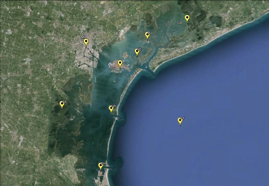
Figure 1: Map of the tidal stations Data source
ISPRA elaboration on data Municipality of Venice - Forecast Center and Tides and Reports and ISPRA Data legend
Station: PT: Piattaforma Acqua Alta; BU: Burano; CH: Chioggia Vigo; FR: Faro Rocchetta; GB: Grassabò; MA: Marghera; Se: Sant'Erasmo; PS: Punta Salute; VA: Valle Averto |
Thumbnail
Headline
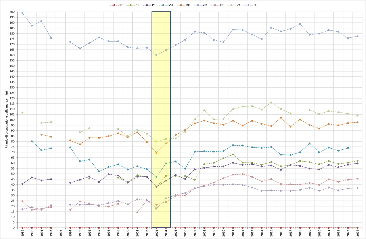
Figure 2: Astronomical tide propagation delays Data source
ISPRA processing on data from the Municipality of Venice - Tide Forecasting and Reporting Center and ISPRA Data legend
Station abbreviations: PT: High Water Platform; BU: Burano; CH: Chioggia Vigo; FR: Rocchetta lighthouse; GB: Grassabò; MA: Marghera; SE: Saint Erasmus; PS: Punta Salute; VA: Valle Averto |
Headline
Table 1: Delay in tidal propagation in the Venice lagoon Data source
ISPRA processing on data from the Municipality of Venice - Tide Forecasting and Reporting Center and ISPRA Data legend
Station abbreviations: PT: High Water Platform; BU: Burano; CH: Chioggia Vigo; FR: Rocchetta lighthouse; GB: Grassabò; MA: Marghera; SE: Saint Erasmus; PS: Punta Salute; VA: Valle Averto |
The substantial stability of the propagation delays of the astronomical tidal wave since the beginning of the 1990s has been interrupted in all the lagoon stations starting from the two-year period 2003/2004 (Figure 2, yellow area): an increase in the tidal propagation delays within the lagoon is in fact appreciable compared to the Platform station, taken as a reference at sea, whose delays remain stable over time. The increase in propagation times is distributed unevenly within the lagoon: since 2019 the delay of the tidal wave is almost 20 minutes greater in the North Lagoon (Burano, Grassabò) and by approximately 15 minutes in the South Lagoon (Chioggia) compared to the two-year period 2003/2004. The historic center of Venice has an increase in propagation times of 15 minutes (Sant'Erasmo, Punta Salute). As regards the Central Lagoon, currently in Faro Rocchetta the delay has increased by almost 20 minutes and in Valle Averto by 25 minutes compared to the open sea (Platform) (Figure 2). These results, heterogeneous among themselves, lead to making some general considerations: the entire Venice Lagoon has undergone, as a whole, significant variations in the tidal structure (Table 1). The non-homogeneity of these variations suggests that the lagoon hydrodynamics have changed significantly, with a modification also of the limits of the areas subject to the influence of one port mouth compared to the other (watershed bands). In particular, based on the evidence, the Lido mouth has expanded its area of influence and that governed by the Malamocco mouth has instead reduced. These results also imply changes to the structure of the tidal currents, which would seem to result in an intensification of the currents fed by the Lido mouth compared to those governed by the Malamocco mouth. Remembering which reconfiguration interventions have recently been completed at the two inlets, we can mention, for the Lido inlet: the creation of the artificial island which in fact clearly separates the flows directed towards the extreme northern lagoon (Burano, Grassabò) from the area of the historic city (Sant'Erasmo, Punta Salute) and the creation of the moonlight to protect the inlet from the Scirocco storms (an intervention also replicated in the other inlets). As regards the Malamocco mouth, however, the width was reduced to build the navigation basin, designed to allow the functionality of the commercial port even in the event of closure of the mobile gates. These are therefore works that have had a certain impact on the propagation of the tidal wave within the lagoon. In particular, they have altered the hydraulic structures of the lagoon with a transformation of the morphology of the lagoon itself, directly affecting the factors that determine the erosion and resuspension of sediments and consequently producing a progressive loss of the characteristic shapes of transition environments, typical of a lagoon mirror.